Annie 's Cabin, Missouri Ridge and 2006 Thinning Projects
Adobe Acrobat File (PDF), 557 Kb
12/20/11
The Salem District of the Bureau of Land Management released the Decision Rationale for the Annie 's Cabin thinning project and Bark submitted a lawsuit in September 2007. The project has been decreased due to red tree vole presence. On recent groundtruthing trips, Barkers have discovered Oregon Slender Salamander. The Environmental Assessment claimed they were not present, however this species has special management requirements. The project falls partially within the Molalla River Recreation Corridor. The following four project areas will affect 6 watersheds (in parentheses) Annie 's Cabin (Upper Molalla River watershed), Missouri Ridge (Rock Creek and Pudding River watersheds), Snakehouse (Little and Middle North Santiam), and Round Mountain (Crabtree Creek and Hamilton Creek). A total of 566 acres will be thinned, including 85 acres of Riparian Reserves. Road construction would include the following a mile of new road construction up to 20 miles of road would be renovated and 0.6 miles of road would be improved. Upper Willamette River (UWR) Chinook salmon, UWR steelhead trout (both threatened species) inhabit areas just downstream, but the BLM has found that the logging May affect is Not Likely to Adversely Affect ' the populations. 246 acres of dispersal habitat for the Northern spotted owl (threatened) will also be logged. '
- Forest Watch Video
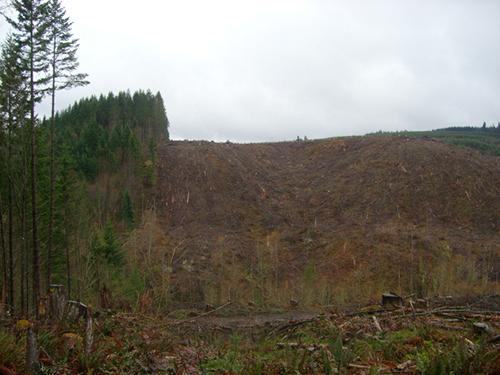
Active logging in the Molalla River area
More... - Judge Rules In Favor of Logging Along Molalla River
 Last Thursday, Judge Michael Mosman came out ruling against Bark in the Annie’s Cabin Timber Sale
More... - Living -- For Now -- In Paradise
Forests owned by the federal Bureau of Land Management make good neighbors -- until the chain saws show up. The Oregonian gets the scoop on Annie's Cabin.
More... - Annie’s Cabin logging bid awarded
Molalla Pioneer Newspaper talks to Bark about the recent sale of the BLM's Annie's Cabin Timber Sale
More...
General Info
- District: BLM
- Total Acres: 1882
- Watershed: Upper Molalla RiverRock CreekPudding RiverLittle and Middle North SantiamCrabtree CreekHamilton Creek
- Basic Location: Approximately 10 miles southeast of Molalla
- Driving Directions: Directions To get to Molalla, take 205 South to 213 South, take 211 East (take a left at Safeway). This puts you on Main Street in Molalla. From the east side of Molalla, follow signs to Feyrer Park. Cross the river and turn right, following signs to Dickey Prairie. Continue south on Dickey Prairie Road about 4 miles past Dickey Prairie Store. Turn right onto the Molalla Forest Road and cross Glen Avon Bridge. Continue until you see signs for trailheads. You can park and enter the area by foot or bike at Hardy Creek Trail head. You 'll find units marked with flagging throughout the area.
- Legal Description: Annie 's Cabin T6S, R3E sections 7, 18, 19,30,31 T7S, R3E, sections 5,6 Missouri Ridge T6S, R2E sections 7,9,16,17 Snakehouse T8S, R3E sections 31,33, T 9 S, R2E, sections 1, 15 T9S, R3E, sections 7, 13 T10S, R2E section1 T10S, R3E, sections 3, 5 Round Mountain T11S, R1E section 33 T12S, R1E, section 3.
Timber Sales
- Annie 's Cabin (566 Acres)
Status: Post Appeal/Lawsuit - Missouri Ridge (287 Acres)
- Snakehouse (834 Acres)
- Round Mountain (195 Acres)
Prescriptions
- Total Commercial Thin Acres: 566
- Total Riparian Acres: 85
- "Purpose & Need:" The BLM 's Stated Purpose of the project These areas are overstocked with trees which slows tree growth increases tree mortality and reduces overall forest health and diversity. ' The BLM has also stated a concern about a potential for wildfire in the area. All the available science says that logging can increase the risk of fire and that the more roads there are the more human caused fire starts there are!'
- Bark's Comments: Just when we thought the project was all done and over the Salem BLM is about to release a Decision Notice for Missouri Ridge. This was originally part of the Annie 's Cabin EA but was removed when Decision Notice was released in 2007.
Roads
- New Road miles: 1
- Reconstruction Miles: 20
Habitat & Species
- S&M Species: Tall bugbane
- T&E Species: Upper Willamette River (UWR) Chinook salmonUWR steelhead trout
- Additional Species Info: 246 acres of dispersal habitat for Northern spotted owl will be affected. Also, some marginal habitat for the Oregon slender salamander will be affected.
Updated 1/19/11


