Mudslide photo spurs look at logging practices
Major landslides in Washington force Weyerhaeuser to assess the risks of logging on slopes

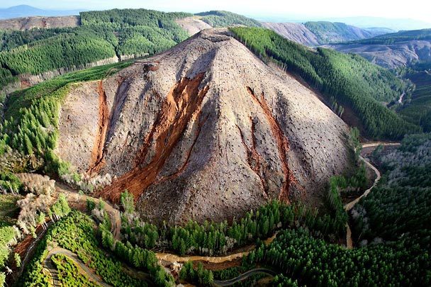
The aerial photo of the bare slope and slide areas in the Stillman Creek drainage raised concerns at Weyerhaeuser, enough so that corporate officials did their own flyover, scouting landslides there and elsewhere in the Northwest.
Seattle -- By Hal Bernton
Nearly 3 ½ years ago, Weyerhaeuser asked state officials for approval to clear-cut 106 acres on a steep mountain slope fronting on Stillman Creek in Lewis County.
This was a slide-prone drainage. But a Weyerhaeuser geologist found "no potentially unstable areas" in the area to be harvested and the state approved the logging.
Earlier this month, the huge storm that enveloped Southwest Washington triggered numerous slides on this slope. Slides crashed into Stillman Creek, a major tributary of the South Fork of Chehalis River, adding to the destructive mix of mud, wood debris and floodwaters that inundated homes and farms in the Boistfort Valley west of Chehalis.
This slope captured the eye of Seattle Times photojournalist Steve Ringman as he made a helicopter flight over dozens of slides in the Stillman Creek drainage. His photograph, first published last Sunday, offered a stark view of the storm's effects on a tract of heavily logged lands.
The photo raised concerns at Weyerhaeuser, the timber giant that has sought to cultivate an image of solid environmental stewardship. In recent days, corporate officials did their own flyover, scouting landslides there and elsewhere in the Northwest, where Weyerhaeuser owns more than 2 million acres.
"This storm was a catastrophic event, a natural disaster," said Frank Mendizabal, a Weyerhaeuser spokesman, noting that a Stillman Creek gauge recorded nearly 20 inches of rainfall in a 24-hour period. "That said, what I can tell you is that we are going to look at this particular unit and others, and see what effects the storm had, and see if we need to make any changes in our practices."
The damage also will be investigated by the state Department of Natural Resources, which regulates logging practices.
"We're going to look at how the storm tracked across the landscape," said Eric Schroff, southwest region manager for the department. "It's very much in our interest to see if there is anything that we can learn from this."
Others questioned why that slope was clear-cut in the first place.
"Weyerhaeuser has spent millions of dollars advertising how green they are," said Peter Goldman, founder of the Washington Forest Law Center. "But the public has to have a debate. Is this the kind of industrial forestry we want?"
Increased slide risk?
The Pacific Northwest has plenty of unstable slopes that even when thick with trees may slide as winter rains saturate the ground. Numerous studies have concluded that clear-cutting may increase slide risks by from two to five times, and building roads on those hillsides poses a still-higher risk.
"These big storms are the true test of our watershed management," said Fred Swanson, a Forest Service geologist in Oregon.
A 2001 overhaul of the Washington Forest Practices Act beefed up rules that regulate logging on steep, slide-prone land. When logging would likely trigger slides that put public resources or public safety at risk, the rules enable state officials to restrict the harvest.
The Stillman Creek tract proposed for logging in 2004 had slopes of up to 50 degrees, well above the threshold regulators used to define steepness.
So Weyerhaeuser asked a geologist to review the harvest area. That geologist walked the harvest area with a forester engineer and made field notes, according to Mendizabal, the Weyerhaeuser spokesman.
The geologist also consulted a detailed 1994 watershed analysis compiled under a Weyerhaeuser contract that designated this area as suitable for logging. That analysis mapped that hillside as part of a larger "moderate risk" landslide-zone area of more than 3,000 acres. Within that zone, there had been more than 80 landslides and debris torrents.
Nearly three-quarters of those slides had reached the streams, the analysis noted.
Weyerhaeuser officials say slide risks prompted them to trim the original harvest unit and leave some additional area of uncut trees.
But within the 106-acre site, the geologist found "no potentially unstable slopes."
State officials did their own review. In an office summary, they checked off boxes that indicated the larger Stillman Creek drainage contained highly erodible soils, unstable slopes and unstable soils.
But they still approved the clear-cut.
State officials say the Weyerhaeuser geologist's assessment was key to that approval.
"It was a very important thing. Without that, we would have potentially had to bring in one of our own geologists," said Schroff, of the Department of Natural Resources.
Focus on recovery
It will be weeks before Weyerhaeuser and other forest landowners tally the damage from the December storm. In an initial review of the mountain depicted in the photography, Weyerhaeuser officials found one area spared from logging is still standing. Another uncut area slid.
Meanwhile, in Lewis County, the focus is on recovery. For those who live along the South Fork of the Chehalis, there are difficult decisions to make about whether to boost up foundations and rebuild, or move to higher ground.
Many do not want to get into a blame game about what, apart from the rain, might have contributed to their misfortune.
But there are flashes of anger.
Rod Rector, a Weyerhaeuser employee whose home was flooded, attacked state rules that require standing trees to be left alongside streams and some logs to be left in them. The slides and floods then carried some of that wood downstream.
Others find fault elsewhere. A few days after the floodwaters receded, Paul Richied, a 37-year resident of the Boistfort Valley, parked his truck beside a farm field full of silt and debris.
"When you log off the whole damn hillside, you get into trouble," said Richied. "You got to leave some trees behind."
Hal Bernton: 206-464-2581 or [email protected]


